


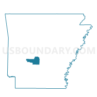
Harrison Voting District, Hot Spring County, Arkansas
About
Outline

Summary
| Unique Area Identifier | 526623 |
| Name | Harrison Voting District |
| County | Hot Spring County |
| State | Arkansas |
| Area (square miles) | 43.75 |
| Land Area (square miles) | 43.75 |
| Water Area (square miles) | 0.00 |
| % of Land Area | 99.99 |
| % of Water Area | 0.01 |
| Latitude of the Internal Point | 34.20337950 |
| Longtitude of the Internal Point | -92.79741180 |
Maps


Graphs
Select a template below for downloading or customizing gragh for Harrison Voting District, Hot Spring County, Arkansas


Neighbors
Neighoring Voting District (by Name) Neighboring Voting District on the Map
- Voting District 6, Dallas County, AR
- Brown Springs Voting District, Hot Spring County, AR
- Clear Creek Voting District, Hot Spring County, AR
- Dover Voting District, Hot Spring County, AR
- Midway Voting District, Hot Spring County, AR
- Ouachita Voting District, Hot Spring County, AR
Top 10 Neighboring County Subdivision (by Population) Neighboring County Subdivision on the Map
- Midway township, Hot Spring County, AR (914)
- Ouachita township, Hot Spring County, AR (660)
- Dover township, Hot Spring County, AR (616)
- Clear Creek township, Hot Spring County, AR (392)
- Harrison township, Hot Spring County, AR (262)
- Brown Springs township, Hot Spring County, AR (173)
- Willow township, Dallas County, AR (92)
Top 10 Neighboring Unified School District (by Population) Neighboring Unified School District on the Map
- Malvern Special School District, AR (18,325)
- Harmony Grove School District, AR (5,284)
- Ouachita School District, AR (1,992)